|
|
ITERMEDIATE REPORT for 2004 Section 2: Development
of methodological basis for monitoring of biodiversity Subsection 2.1:
Development of methodological basis for monitoring of biodiversity
in Russian forests Curator of the section: Academician
A.S. Isaev |
|
|
Main objectives:
It is necessary to be informed with different
types of nature management and its consequences to understand tendencies
of contemporary forest biodiversity forming (changes of tree-species
composition and age structure, decreasing steadiness to unfavorable
factors). The report contains characteristics of main nature
management types within the territories of Regional features of forest biodiversity
information obtained in model regions situated in different zonal
and province complexes. Each region has specific features influencing
on forest biodiversity. Negative factors influencing on forest biodiversity
include concentrated cuts, extensive fires, mass insect invasions
and industrial pollution. According to the last forest inventory
data the area of burned and dead stands is almost 4 times more than
area of non-forested cuts for the whole country. Annually within
framework of actively fire protected area (area of forest fund)
about 30 thousand forest fires occur, injuring forests over an area
from 2 up to 5 million hectares. The most of burned forests
are situated in To detect and to assess consequences of anthropogenic
transformation of forests over
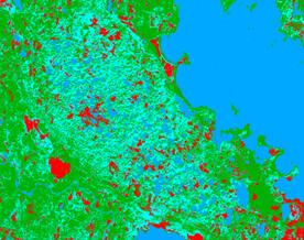
Fig. 1. Classified Landsat 7 images of key territories in Karelia: а - after concentrated cuttings without remained fragments of primeval
forests, б
– after intensive clearing economy and selected cuttings of coniferous
stands in past. Colors: green – coniferous forests (prevailingly
spruce), blue – small-leaved forests (prevailingly birch), red –
open cuts and agricultural lands Strong anthropogenic distortions spread
over the In order to assess forests condition over large
areas the priority type is the monitoring of typological (ecosystem)
diversity based on vegetation cover classification accounting geobotany
and forestry approaches. Although the unified classification is
highly urgent it still has not proper methodological basis and it
is the object of constant discussion up to present. So one of the
main results of the Project’ is development of synthetic typology
of forest ecosystems for major natural vegetation zones basing
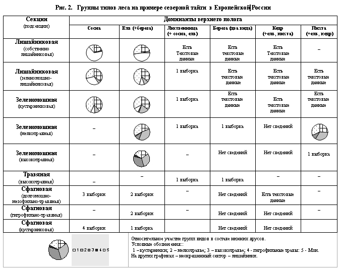
on dominant and floristic classifications comparison. Pointed areas
were also fulfilled for groups of forest types especially rich in
flora . Biodiversity characteristics of the most representative
groups of forest types for each zone of European Russia are performed
in matrix tables (fig.2).
At present works on the identification of
species diversity with division of vegetation into main life-forms is
preparing for forests of northern and middle taiga, as well as for
broad-leaved forests. The most part of this work has been fulfilled for light-coniferous
and dark-coniferous forests. Subsequent inventory of typological diversity of
zonal ecosystems of other regions of Derived typological characteristics are an effective
form of semantic information which may be used to connect different
attributes of each group of forest types. These groups related by
ecological properties, topographical features, and succession status
may serve for biological interpretation of space images and
biodiversity parameters obtained at the imagery base. As a result of analysis of national scientific
references the card index of main groups of forest communities has
been created for taiga zone of European Russia; the terminology
of Russian names has been unified. Computer database PRODROMUS has
been created; it includes list of forest vegetation syntaxons for
European Russia as well as database of field geobotanical descriptions
- FORUS. This is the basis for database on main forest types for
European Russia forming. Another basis for implementation of methodological
approaches to biodiversity monitoring is represented by cartographical
and verbal reconstruction of potential forest vegetation of European
Russia. It is based on the theory of climax communities structure
and mapping of edificator tree species areas as well as constant
species of ground cover. The database of contemporary edificator
tree species distribution created at the base of historical and
modern data (fig. 3).
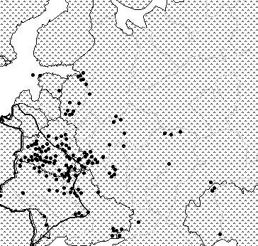
Fig. 3. Contemporary area of Carpinus betulus
and its area in historical period Historical and contemporary areas
of tree species were compared and the group of species has been
detected. Its areas are essentially reduced during last two-three
centuries because of low tolerance to human impact. Maps of pointed
areas created for constant herbaceous plants of boreal and nemoral
ecological-coenotic groups; the area of their combined habitation
discovered, marking spread of mixed coniferous and deciduous forests
in historical period. Experience gathered in study of biodiversity allowed to
begin the generalization of data for different spatial levels. In this connection the main procedures of
biodiversity monitoring were implemented for adopted spatial levels
of biodiversity measurement (local, regional, national). They are
1) collection of field data, 2) analysis of remote sensing data,
3) interpolation of biodiversity measuring parameters for territory
of higher level. Field surveys on discovery
and description of main succession types and assessment of spatial
temporal dynamics of forest areas were implemented in
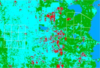
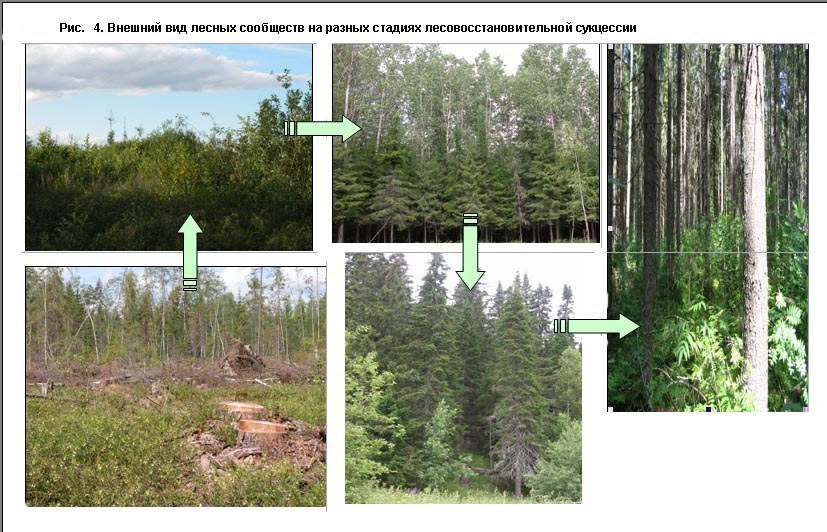
Fig. 4. Specific and typological diversity regularities
of reforestation successions were discovered and described.
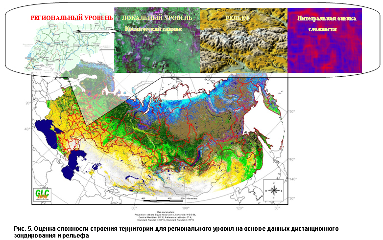
Data of space monitoring of forests are considered to be the
most important components of information cover for assessment of regional
ecosystem diversity as well as for modeling of natural and anthropogenic
forest dynamics. Analysis of some landscape indices allowed to receive
integral assessment of territory structure complexity determining
the biodiversity of terrestrial ecosystems (fig.
5).
Combination of terrestrial surveys data and
remote sensing data gave an opportunity to interpolate information
on local biodiversity measuring to the regional level; and therefore
the vegetation map was compiled showing the most important properties
of its diversity. The base of such a typological data generalization
was presented by combination of local dotted data with regional covers
accompanying by quantitative analysis of obtained characteristics.
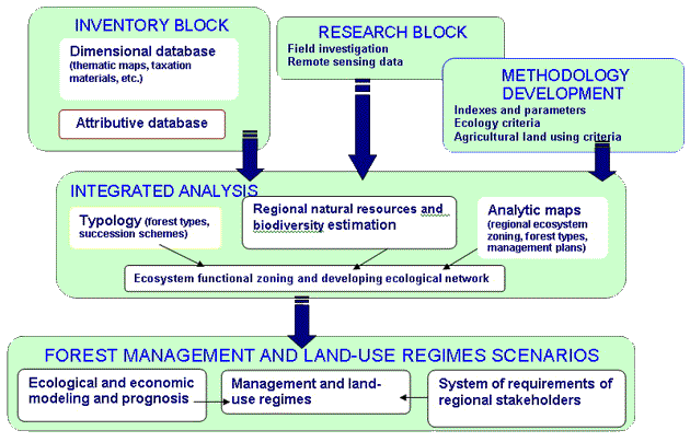
Efficiency of forest monitoring is determined
by developed information base on state and dynamics of forest
fund, its environmental and resource potential, as well as knowledge
about forest ecosystems functioning. In this connection the scientific
base was developed with the purpose of inventory and monitoring of
biodiversity for Russian forests. The scheme of multi-level GIS was
established, supplying monitoring and assessment of human impact on
natural territorial systems (fig. 6). Also the algorithm of sequent
creation of biodiversity thematic maps was developed at regional and
federal levels. Complex base of standard information data on biodiversity
was formed for Russian forests. For the purpose of conservation of forest biodiversity
within the framework of sustainable forest use it is necessary to
develop optimal sceneries of nature management on the base of environmental and economic models. In
this connection the model of productivity and carbon and nitrogen
cycles in forest ecosystems was developed and used to predict biodiversity
dynamics under different sceneries of forest use (EFIMOD-PRO). Thus this year the main attention was paid to
development of methodological basis of biodiversity monitoring. It
is based on comparative assessment of spatial and temporal dynamics
of forest forming process and contemporary state of forests. Some
scientific and methodological tasks had been successfully decided
and following stages of further researches are marked:
Fig. 6. Thematic content of forest monitoring
GIS 1) improvement of inventory of typological diversity for zonal forest
ecosystems of European Russia; 2) development of forecast methods
and accounting algorithms for biodiversity dynamics variants under different
sceneries of nature management; 3) development of methods for
biodiversity assessment at the base of terrestrial and space information for
instance of different regions; 4) improvement of methods for
quantitative assessment of forest ecosystem diversity; 5) development
of methods for assessment of past, present and potential forest
biodiversity for different zonal and provincial complexes; 6) development of strategy
for conservation of ecosystem and landscape diversity. |
|||||||||||||||||||||||||
![]()
© All rights reserved.
Центр по проблемам экологии и продуктивности лесов РАН, 2005.